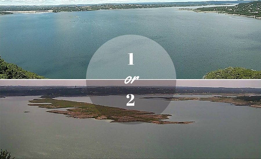
On May 13, 2015, the once elusive rain clouds settled over the Texas Hill Country and the optimistic chatter about filling up Lake Travis began.
At that time, Lake Travis was only 38% full at 630′ and Sometimes Island was looking more like a peninsula.
Today Lake Travis is full at 681.1′ … and it’s beautiful!
Even though February and March have been somewhat dry, the Highland Lakes (Buchanan and Lake Travis) have continued to hold steady. In fact, Lake Travis is nine feet above average and the combined storage of lakes Buchanan and Travis is at 96% full.
But managing a full Lake Travis is a real balancing act. You have a growing population in Austin. Water releases. An ever-increasing demand for water. And it all gets coupled with possible flooding.
What water releases are planned as summer approaches? And where will water levels be when summer is over?
Water for one million+ people
If you didn’t already know, the Highland Lakes and Colorado River supplies water for more than one million people. Quite the difference from just 10 years ago. Plus, our water is used for businesses, industries and agriculture in the lower Colorado River basin.
So what about water releases and the rice farmers?
Well, as we reported in July 2015, the Water Management Plan did get revised in 2015 and a newly enhanced water plan is in place for 2016.
The days of “open supply” for agricultural use are over. This means a limited amount of interruptible stored water will be available for agricultural irrigation in the lower basin from now until August 2016 for a first crop.
Interruptible stored water is for agricultural use and it can be cut back or cut off during situations that put a strain on our resources like droughts.
The water we use (residential) is referred to as firm water, which is supplied on a constant basis, even during one of the worst droughts in history.
Flood preparedness
Reporting about the rebirth of Lake Travis was bittersweet last year because as we celebrated the astounding lake levels, we grieved for the devastation left behind by the floods.
Our Facebook feed was full of images of our Lake Travis community members pulling together relief efforts for many residents who lost homes and even worse, lives.
In light of what happened last year, LCRA recently installed five new stream and river gauges in Bastrop and east Travis counties to prepare for future flooding. Based on our lake levels, this is a very real concern if heavy rain heads our way.
The data from these new gauges will supplement existing real-time data LCRA gets from more than 275 automatic gauges in the lower Colorado River basin. This is how you get information about lake levels, streamflow, river stage, rainfall totals, temperature and humidity.
A peek at lake levels through September
According to LCRA, there are a few different ways our lake forecast will shake out through September 2016. Variables include the weather, of course, and the newly implemented Water Management Plan.
If we see wet conditions, Lake Travis could stay up around 680′ until July. On the other hand, if we see dry or extreme dry conditions, levels will start to gradually drop off and land at 650′ by September 2016.
The good news … even if we get hit with dry conditions for the next few months — even at our lowest possible level — we will still be way above our formerly sad 620′ digits. Whew!
